13 Jul Google Street View comes to Sable Island
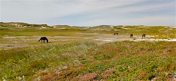
At first glance, it looks like one of those iconic shots of Sable Island horses, but it’s actually a scene from Google Street View. This week, Street View added Sable to its Trekker program, which features virtual off-road tours of spectacular sights around the world.
Danielle Hickey, Parks Canada Acting External Relations Manager for Mainland Nova Scotia, lugged Trekker’s portable, backpack version of the Street View car camera around a central section of Sable last September, collecting a connected series of 360° images. The thick blue lines in the image below give a rough idea of the paths she followed.
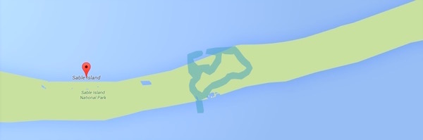
[UPDATE] Since posting this, I’ve learned the blue lines follow the primary walking route Parks has designated for escorted visits by expedition vessel tourists. For the last three years, in partial fulfillment of Harper-era parks minister Jim Prentice’s much-criticized vision for developing Sable’s tourism potential, Parks Canada has allowed adventure tourism companies to bring visitors to the island. The vessels anchor offshore. Staff and passengers come ashore, where they are met by Parks Canada staff, who escort them on these trails.
Some links:
- Here’s where Hickey encountered the grazing horses pictured above.
- Here she came upon a herd of seals basking on the island’s northern shoreline.
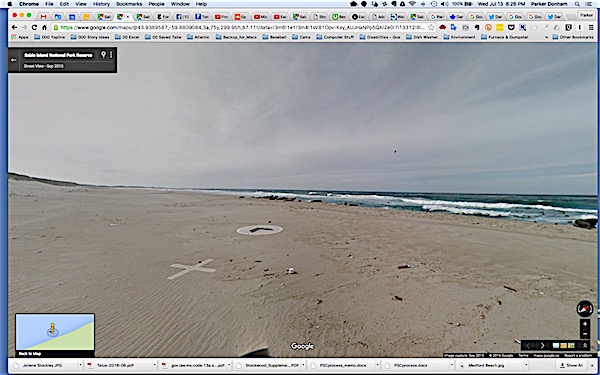
- Here’s a moving image of a shallow, freshwater pond she hiked past.
There’s a bit of a knack to navigating Google Street through, even more so with Trekker, which lacks the implicit guidance you get by following a street. If you run your cursor around the screen, a ghostly white X will appear—sometimes accompanied by an arrow in a circle showing the direction of travel.
Clicking on the arrow (or if there is no arrow, clicking anywhere near the X) repositions your virtual vantage point on the X. By repeating this process, you can mimic a walk along the beach. Deft use of cursor can sometimes can cause an X to appear further along the path, allowing a faster virtual journey. You can also drag any of the images around through 360°, creating the sensation of turning left and right, or looking up and down.
The whole process has a haphazard feel, like a drunken game of capture-the-flag. It’s nowhere near as good as going to Sable Island, but it’s not a bad way to pass time surfing the net.
 If you follow Hickey’s hike through the scene with the basking seals, you’ll see the seals disperse into the water upon her approach. (The seals’ ID tags have been blurred out in accordance with Canadian privacy laws.)
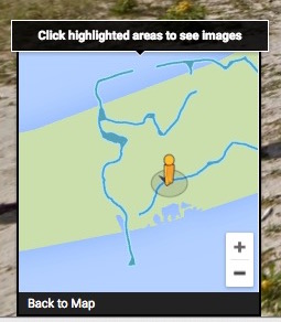
Placing your cursor inside the small blue and yellow box at the lower left corner of the screen brings up a resizable key, with blue lines showing a rough approximation of Hickey’s course. (It’s quite rough, given it shows her to be in the water much of the time, which she was not).
The little yellow figure, known officially as Pegman, shows the approximate location of the current images. Dragging Pegman to a new point along the blue lines will load imagery from that spot.
The Street View images from Sable are not perfect. Some appear partly or totally out of focus, and disembodied parts of the camera and its operator, normally obscured on Street View, occasionally show up. But on the whole, it’s a welcome interactive addition to catalog of Sable still and video imagery.
Portions of five other Canadian National Parks have been recorded on Street View Trekker. Find information on how to borrow the Street View Trekker camera backpack here; fill out an application to borrow it here. (Note, you have to represent a nonprofit organization, government agency, university, or research group, but otherwise, the process is not arduous.)
MacNab’s Island is untrekked, an oversight some Contrarian reader should be well positioned to overcome. Let me know.