28 Oct Eastport Maine v. Cape Breton’s serendipitous superport
[See correction and clarification at end.] Two months ago, Atlantic journalists James and Deborah Fallows began traveling around the United States in a small plane, visiting relatively obscure cities in a quest to find out what makes some thrive while others struggle.
They spent much of last week in Eastport, Maine, hard up against the New Brunswick border. Jim’s initial blog posts bespeak a community well on the way to recovery, populated by leaders determined to go the distance. Since Eastport shares much in common with struggling Atlantic port communities, Maritimers might want to perk up their ears.
In a post last week, and again on the weekend, Jim focused on two factors residents believe will play a role in Eastport’s potential for economic prosperity: the depth of its harbour, and its proximity to Europe.
As you’ll hear, a group of ambitious people in the city are trying to use the port’s unique capacity — and its proximity to Europe, and its potential proximity to Asia as northwest passages through a warming Canadian arctic become more frequent (they are already happening) — as one foundation of its hoped-for economic revival.
and
As mentioned yesterday — and as cited non-stop by local port authorities — Eastport has the deepest natural harbor in the continental United States, at 60+ feet. Its siting, “remote” from the rest of America’s perspective, is also a potential strategic plus.
To buttress the point, he offered three maps, created by the nifty online Great Circle Mapper, showing how much closer to Europe Eastport is than Boston, New York, or Miami. And not just from Europe, but from the African ports of Casablanca and Dakar. Here’s the London map:
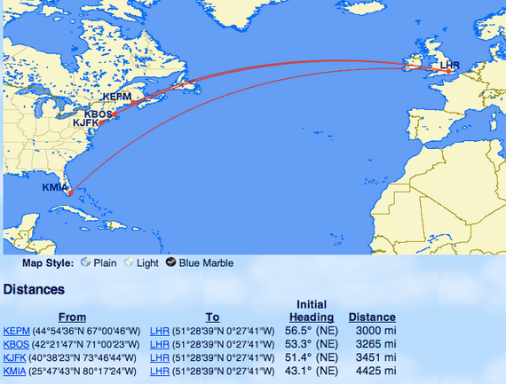
Compared to Boston, Eastport has the potential to save vessels more than 500 miles* in a round trip to London; 900 miles when compared to New York. All that means time, fuel, and money saved. Similar maps made the same point with the two African ports.
All this rang a bell with David Ryan, a Long Island, filmmaker, boat builder, and yachtsman, who happens to be a mutual friend of Jim’s and mine. In an email to both of us, he wrote:
I heard the same thing when we were in Port Hastings [on the Strait of Canso in Cape Breton Island], Nova Scotia, back around 2003. There was no reason a local should have been telling me in particular that they had 60 feet of water, were ice-free year round, and right on one of Canada’s main train arteries, yet I was; so I take it this is something that all Post Hastings boosters tell anyone and everyone who visits.
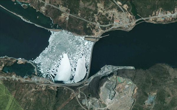
One curious feature of the superport formed by the eastern half of the Strait of Canso is that it was accidental. Construction of the 4,544 ft, rock-filled causeway connecting Cape Breton Island to the mainland in 1955 had the unanticipated result of creating an ice-free, deepwater harbour. This image from Google Earth shows how the causeway traps the seasonal ice flowing down from the Great Lakes and the St. Lawrence Seaway, keeping the deep waterway east of the causeway free from ice. Voilà! A superport.
For a time, the superport turned the nearby community of Port Hawkesbury into something of a boom town, albeit one that never quite lived up to its potential. An oil refinery, a gypsum plant, and a heavy water plant all eventually failed—the heavy water plant spectacularly so**—but the paper mill still operates at reduced capacity, as does a tank farm, a bulk coal facility, and a massive rock quarry. Together they make Port Hawkesbury Canada’s second largest port by tonnage, after Vancouver. A biomass electrical generating station officially opens in Port Hawkesbury this Wednesday, but hopes for a container terminal remain elusive (though not as elusive as Sydney’s parallel pipe dream).
Thinking about all this history led me back to the Great Circle Mapper, where I reconstructed Jim’s images of the Great Eastport Advantage — this time including Port Hawkesbury. As I expected, the Nova Scotia port has as much of an advantage over Eastport as Eastport has over Boston.
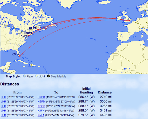
Here is the map showing distances to Casablanca:
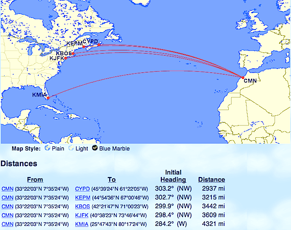
And here is Dakar.
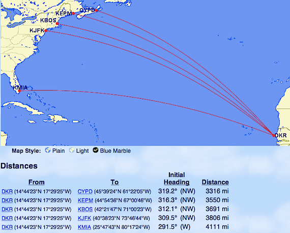
The Canso Superport wins all three.
Whether this makes it any more likely than Eastport to foster lasting economic growth, and what other factors might affect the two communities’ prospects, is a much tougher question, and a topic for another day. We may get some hint, however, from an apocryphal Presbyterian prayer one hears quoted from time to time in Cape Breton:
And more especially do we thank Thee, O Lord, for the Gut of Canso, Thine own body of water, which separates us from the wickedness that lieth on the other side thereof.
* [Clarification] In response to a question from Robert G. McNeil, the units are nautical miles.
** [Correction] Thanks to Stanley Beaton for reminding me it wasn’t the heavy water plant at Port Hawkesbury that proved a disaster. It was AECL’s sister facility at Glace Bay.