21 Mar An archeological baseline for Sable Island
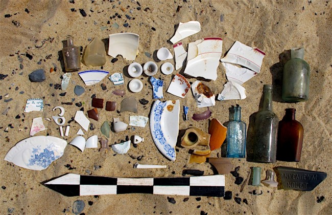
Here’s a random selection of artifacts Parks Canada archaeologist Charles Burke found last summer near the site of the former East Lighthouse on Sable Island. Burke was conducting a baseline survey of archaeological resources to guide preservation and future investigation of artifacts on the newly created Sable Island National Park.
Burke will present the results of his survey in a slide show at 7:30 pm, Tuesday, in Burke Theatre A, Saint Mary’s University. [The meeting may be moved to accommodate the large crowd expected. I’ll update this post if that happens. Nope. The meeting will take place in Burke Theatre A, capacity 160. Come early to assure yourself a seat. ]
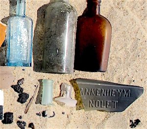 I’ve tweaked the colours in the inset at right to highlight one of the curiosities Burke found: a fragment of a gin bottle manufactured by the Dutch firm Blankenheym & Nolet sometime in the 1870s. He was able to identify it when he discovered someone selling a similar bottle on eBay.
Burke also found a Thomas Alva Edison phonograph with a large ear horn and a wax cylinder dating from 1884.
In a telephone interview, Burke explained some of the challenges Sable presents to archeologists.
Access to the island, which lies 220 km due south of Louisbourg, is expensive and cumbersome. Most trips are by air, which limits the number and size of artifacts that can be removed for preservation and investigation.
Steps archeologists would normally take to protect an important site on the mainland are impossible on Sable: “You can’t just dump a large truckload of rocks on a shoreline to protect resources that are eroding,” Burke said. Sable has no rocks. It’s a narrow, 42 km, crescent of sand that “is constantly shifting,” he said. “Nothing is static.”
Another problem is that excavations in sand don’t meet normal health and safety requirements because the holes are prone to caving in. Excavations on desert sites in the Middle East have massive crews to pull sand back over a huge area—impossible on Sable.
“The layers you normally have to excavate through to get to an arch resource, they don’t exist on Sable,” Burke said. “The wind has blown everything off.”
In normal excavations, archeologists depend on these surrounding soil layers to provide context when the artifacts are located.
On the plus side, there’s been little or no garbage removed from Sable over the years, so virtually everything ever brought to the island remains there, unless wind and sea have washed it away. Artifacts came to the island in one of two ways: they were delivered, mostly by government; or they washed ashore as flotsam and jetsam.
Burke’s survey concentrated on artifacts dating from 1871, when permanent lifesaving stations were established on the island, which has been continuously staffed since then. But his excavations turned up shards of pearlware, a distinctive style of Wedgewood tableware that dates from 1770 to 1820. Burke said there is no historical record of human settlement in that period the record of historical settlement in that period is scant, but he thinks someone must have been living on the island.
He hopes archeologists will eventually discover some evidence of the convict colony set up on Sable in 1589 by a French Viceroy, the Marquis de la Roche. After dropping off 50 or 60 “beggars,” “tramps,” and convicts, together with about 10 soldiers, la Roche returned with necessary supplies only intermittently. When a vessel finally rescued the crew five years later, only 11 had survived.
UPDATE & CLARIFICATION: This morning Charles Burke noted that the lifesaving stations were established in 1801, not 1871. Light houses were established in 1861 and 1873. “There were people on the Island before 1770 too but historical specifics are scant.” My apologies for the error.