Equinoctial Nova Scotia from the sky
At noon yesterday, NASA's Terra Satellite captured a rare, nearly cloud-free image of our fair province....
22 March, 2019
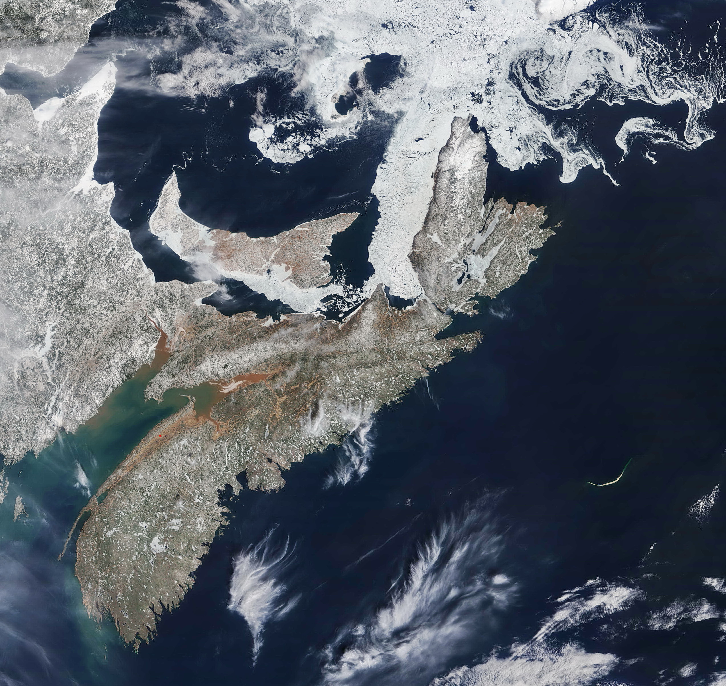
At noon yesterday, NASA's Terra Satellite captured a rare, nearly cloud-free image of our fair province....
"Nine of the 10 warmest years since 1880 have occurred since the year 2000," reports NASA's Goddard Institute for Space Studies. The first years of the new millennium experienced "sustained higher temperatures than in any decade during the 20th century." Goddard, which monitors global surface temperatures, compiled the findings into an animation showing global temperature trends since 1885. The animated map charts differences from the average temperature recorded during a baseline period of 1951-1980. Dark Red zones are two degrees Celsius warmer than the baseline; dark blue are two degrees colder. You can download a copy of the animation here. The average incremental...
After just 17 days on Mars, NASA's Curiosity Rover has detected strong indications of life—and confirmed a familiar adage at the same time. Photo credit: Jet Propulsion Laboratory. Photo-enhancement credit: Peter Barss...
Tense video of mission control scientists at the Jet Propulsion Laboratory at Pasadena, California, as they receive word of the Curiosity rover's descent and landing on the surface of Mars, interspersed with a beautiful animated simulation of the landing. [Video link] And here is the first color photo Curiosity transmitted after landing, showing the landscape to the north of the rover: The image, which shows the north wall and rim of Gale Crater, has been tilted to level the horizon. It's blurry because the camera that took it still bears a transparent lens cap that is covered with dust kicked up during landing....
In just nine days, NASA will attempt to place its Martian Science Laboratory on Mars. It's an operation so fraught with extreme technological challenges, the space agency calls it seven mintes of terror. By the time radio signals reach Earth and alert scientists that Curiosity Rover's perilous descent has begun, it will actually have been over for seven minutes, and rover will be dead or alive on the surface of the red planet. H/T: Alexis Madrigal...
Earlier today, I posted a photograph of uncertain provenance showing Nova Scotia as seen from the International Space Station at night, and wondered out loud where it had come from. The estimable Bethany Horne of Halifax Open File pointed us to this Reddit post, and thence to this collection of NASA astronaut videography, where we tracked down the amazing sequence from which our image — a screenshot, as it turns out — was clipped. Check out this gorgeous time-lapse video from the space station's January 29 pass up the East Coast of North America, starting at the southern edge of the Gulf of...
A view of Nova Scotia, New Brunswick, and parts of Maine and Quebec, taken from the International Space Station. Click the image for a larger version. The bright spot at the left side is Montreal Quebec City;* that on the middle right is Halifax. Other bright spots include (left to right) Bangor, Saint John, Moncton, and Charlottetown. Close inspection reveals Truro, New Glasgow, Antigonish, Port Hawkesbury, and Sydney. The St. Lawrence River appears as a string of lights heading northeast from Montreal, and the Gaspe Peninsula is outlined in light. I believe the aurora borealis accounts for the greenish hue on the horizon. A...